


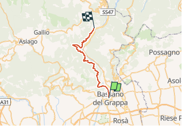
Alta Via del Tabacco

SityTrail - itinéraires balisés pédestres
Tous les sentiers balisés d’Europe GUIDE+

Length
33 km

Max alt
659 m

Uphill gradient
2027 m
Km-Effort
60 km

Min alt
107 m

Downhill gradient
1960 m
Boucle
No

Signpost
Creation date :
2022-02-17 11:05:01.355
Updated on :
2022-03-02 02:35:01.743
13h36
Difficulty : Very difficult

FREE GPS app for hiking
 SityTrail
IGN / Geographical institutes
SityTrail Plus
The world is yours!
About
Trail On foot of 33 km to be discovered at Veneto, Vicenza, Bassano del Grappa. This trail is proposed by SityTrail - itinéraires balisés pédestres.
Description
Trail created by Associazione Alta Via del Tabacco.
Website: http://www.altaviatabacco.it
Photos


Positioning
Country:
Italy
Region :
Veneto
Department/Province :
Vicenza
Municipality :
Bassano del Grappa
Location:
Unknown
Start:(Dec)
Start:(UTM)
712287 ; 5071844 (32T) N.
Comments